Summer 2018 was the summer of National Parks. Yellowstone and Grand Teton marked our 7th and 8th National Parks of the year. We drove up to Wyoming the weekend after Labor Day and stayed at a cabin just outside of Yellowstone. The mornings were crisp and cool and the days were sunny and warm. It was a perfect weekend to get out of town and enjoy nature. Without further ado, a massive photo dump from our weekend:
On a beautifully cool and sunny October morning, I ran the Elk-Kings 50K in the Tillamook State Forest in Oregon. I’ve never been much of runner, but I got it in my head last year that I wanted to push my body to see just how much it was capable of. I followed a 16 week training program and felt prepared both mentally and physically when October 13th rolled around.
The race started at the Jones Creek Day Use Area. The weather was crisp and cold and there was a gorgeous fog blanketing the forest. The trail was a double out and back; it went out for 4 miles along the Wilson River before turning back to hit the starting point again and head out in the other direction for 12 before turning back around and finishing at the Tillamook Forest Center. There was roughly 5,600 ft. of elevation gain by my Garmin (though the website says it was closer to 6,500 ft.) with the majority occurring in the second half of the course. (source)
The first 11 miles went by quickly. The trail was full of rolling hills and the energy was high. I rolled my ankle at mile 4 – the terrain was much softer than the rocky ground I trained on in Utah – but I was able to walk it out and keep moving forward. Though it was cold when the race started, the sun came out and I was able to shed my outer layer around mile 8. Matt and Snickers met me at the second aid station around mile 11 to give me a fresh water bladder and take my shirt.
The trail started to get much more difficult after that point. We crossed a bridge and climbed about 1,200 ft. in 3 miles. There was a steep downhill followed by some rollers and another climb before hitting the turn around point at mile 19. At this point my right IT band was getting inflamed from all of the downhill and my knee was in pain (you can see it on my face in the photos below). Luckily Matt came to my rescue with some Ibuprofen and some motivation and I was on my way again.
The return was HARD. The 1,200 ft. we climbed on the way out was compressed into 1.5 miles on the return and my glutes and hamstrings were on fire. I wanted to stop so many times, but literally pushed my legs up that hill. At this point I knew I was 5th place female – the lady in 4th place was behind me in the first half, but left the aid station before me – and thought if I pushed it I could potentially catch up to her. I was never so relieved as when the trail went down again to the aid station at mile 29. From that point, it was 2.75 miles of rolling hills to the end where Snickers and I crossed the bridge to the finish line.
Since I did pretty much all of my training solo, being in a race environment was both foreign and invigorating. I pushed myself harder than I probably would have otherwise. I finished 31.76 miles in 6:09:13 by the race time (5:59:44 moving time – I stopped with Matt and Snickers at a few aid stations), which was far better than I could have hoped. Going in I just wanted to finish under 7 hours with a goal in the back of mind of 6.5, so to finish just over 6 hours was amazing for me. I was 21st overall, 4th place female (out of 30), and 1st place female in my age group (the top 3 overall weren’t eligible for age group prizes, so I technically finished 3rd in my age group 🙂but I’ll take the win).
A big thanks to Matt and Snickers for being my cheerleaders and support staff all summer and to the Go Beyond Racing crew who put on an amazing race.
The Stansbury Crest Trail to Willow Lake is a 7 mile out and back hike in the Wasatch Cache National Forest. It is ~50 miles west of Salt Lake City and the last few miles are on an unpaved gravel road. The trail is lightly trafficked with 2,000 feet of gain over the course of 3.5 miles. At the end, you’re treated to lake surrounded by cliffs – it was muddy and a bit dried up when we went (end of a hot summer) but it’s likely full in the spring and early summer from snow runoff. We ran into some cattle towards the end enjoying the shade, but otherwise it was a nice, peaceful hike. The leaves were already starting to change colors in early September, which made for a picturesque drive through the canyon on the way out.
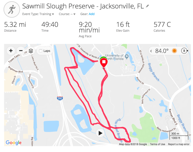
Sawmill Slough Preserve – Jacksonville, FL
Sawmill Slough Preserve is a preserve at the University of Northern Florida in Jacksonville, FL. I was able to get out there while I was at work and do about 5.5 miles on a few of the trails: the Gopher Tortoise Ridge Trail and the Goldenrod Trail. The trails are very flat and easy, and run through a tree grove. They’re not the best maintained – many of the bridges are missing boards – but it’s a good option close to the city. None of the trails are very long, but doing a few loops can get you some decent mileage.
Military Reserve is a 728 acre area of land in the foothills of Boise. It is filled with miles and miles of trails suitable for both running and biking. The trail system in Boise connects a couple of different nature areas including Military Reserve Park and Camels Back Reserve. Beth did a 15 mile run through the hills with Matt and Snickers joining for the last two one day and went back during the week for some shorter runs. The hills are rolling and sandy, making for a relatively easy run. The trails are not shaded so we wouldn’t recommend them for hiking (it’d be a relatively boring hike), but they were perfect for getting mileage on a cloudy fall day. There are so many trails it’s easy to do as much or little as you’d like. Snickers thoroughly enjoyed doing a couple of shorter runs through the area.
The Table Rock Trail is a 3.5 mile, heavily trafficked trail. The trail climbs approximately 890 ft. up to the mesa, and the uphill climb makes it moderate difficulty.The trail starts by an old penitentiary, which you get a nice view of as you climb the hill. With plenty of breaks to catch your breath, it’s a very doable trail offering a great view of the city and canyon from the top.
We’ve been a little silent over here lately. Life has gotten busy and we’ve just been enjoying our time. In the last month we: visited Yellowstone and Grand Teton National Parks, packed up our belongings and said ‘goodbye for now’ to Utah, traveled for work, spent a few weeks in Boise, and popped up in Oregon. So, without further adieu, here’s a rundown of our brief time in Boise.
We chose Boise for one reason: it was the largest city roughly halfway between SLC and Portland. While it’s a small college town, it packs a big punch. We stayed in an extended stay hotel right near Boise State University and Ann Morrison Park. The park along with a greenway that ran along the Boise River were great for walking Snickers. We were there at a great time of the year – the leaves were changing colors and the temperatures were perfect. We were also in walking distance to downtown and the Capitol – there were great parks all around including a beautiful rose garden near the Boise Zoo.
Snickers at the Boise Rose Garden
Train bridge walking path – Downtown Boise
Boise Dept
The downtown area boasts plenty of restaurants and breweries in addition to art installments. Freak Alley is one such art installation where local artists are able to paint murals on the buildings; it’s constantly evolving and new murals are added every few years – either painted over or incorporated into existing art.
Below are a few places we tried and enjoyed during our short time in town:
White Dog Brewery: expansive collection of beers and a tasty food truck – Smoke and Thyme – outside
Gas Lantern: bar next to White Dog serving up unique cocktails in a modern atmosphere. Heidi got a drink that had toasted meringue on top and tasted like a lemon meringue pie!
Spacebar Arcade: you know we love a good barcade, and Spacebar fit the bill. Great basement space with a decent beer and wine selection and plenty of pinball and arcade games.
The Stil: ice cream shop scooping up delicious flavors and ice cream and beer flights!
Payette Brewing: extensive beer selection and great outdoor space. Good for dogs, and, unfortunately, kids.
Tree City: tasty smoothies and simple sandwiches. It was perfect for a quick, healthy lunch.
Dawson Taylor Coffee Roaster: coffee roaster right by the university. Roasts were a bit hit-or-miss, but the lattes were quite tasty.
As if that wasn’t enough, we also got to enjoy quite a few hikes/runs in the trails around the city. Boise is nestled in the foothills of the Rocky Mountains. While the mountains aren’t as looming as those in Colorado or Utah, the view of the hills from the city are gorgeous in their own right. The main areas are Military Reserve Park, Camels Back Reserve, and Table Rock. There are miles upon miles of trails connecting all of the parks and they’re filled with mountain bikers and runners any day of the week.
While not a place we would hang our hats, it was a great stopover destination.
Upper Big Water is a trail in Millcreek Canyon – 20 miles southeast of Salt Lake City. Millcreek Canyon is a State Park in Salt Lake County that has miles of hiking and biking trails. On odd numbered days, no bikes are allowed on the trails and dogs can be off-leash. Snickers and I set out to do the Upper Big Water trail to Dog Lake and return on the Little Water trail. It was a 5 mile loop that wound through the pine forest to a large lake. The Big Water Trail is longer than Little Water, but isn’t very steep; Little Water is a much shorter distance, but is much rockier and fairly steep. We chose to hike up Big Water and run down Little Water. The lake at the top was filled with dogs cooling off, which was a nice break before the descent. The wildflowers were in full bloom in early August making for some beautiful scenery. The trail is pretty heavily trafficked – we probably wouldn’t do it again – but it was nice to get into some elevation to have a break from the heat and experience some shade.
The South Deuel Creek Trail in Centerville is a 4.3 mile lightly trafficked trail. The trail gains roughly 1,400 feet over the first half and runs along a creek. Snickers enjoyed the multiple creek crossings and the shade from the trees was much welcomed. About a mile in, there’s a rope swing and there are numerous campsites along the way. The trail ends at a small waterfall which you can view from both the top and bottom. It was a very enjoyable, short hike close to the city.
The Midmountain Trail is a 25 mile, point-to-point trail in Park City that can be accessed at a number of points for anywhere from a 9-25+ mile hike. We went on a Saturday morning and, aside from two 1/2-1 mile sections where the trail met up with other bike trails, it was very lightly trafficked. The trail itself was relatively easy. There are very few steep inclines and the trail isn’t too technical. The elevation gain was 2,500 ft, but the trail is overall downhill (though it didn’t feel like it!) with an elevation loss of 3,186 ft. The trail is very well marked, though I did get off at one point and ended up adding 1 mile to the expected distance. We went slower than normal mainly due to the altitude – Park City is at 8,000 ft, so even a slight incline left us winded. Beth did 26.5 miles for a long training run, and Matt and Snickers did about 9 miles starting at the end and meeting up with Beth around mile 21.5. Park City is a great place to get on the trails because there’s a lot more shade and the elevation makes it much cooler than in the city. This is a nice, gradual trail to log some serious miles. Udpate – I ran into two moose on the run! Running in the mountains has its perks.
Whew, the summer truly flew by. We haven’t done a progress report since early June, so this is long overdue. Most of our posts have been about hiking – with a few recipes thrown in for good measure – but we haven’t popped in for a proper life update. So, here goes.
June, July, and August came and went faster than we expected. We had a couple of visitors and some personal trips planned, which led to busy few months. We went to southern Utah with Matt’s parents, Moab with Beth’s parents, Beth went to Boston, and Matt went to Vegas and on his annual fishing trip to Canada.
We were initially going to head to our next destination at the end of August, but due to some job flux and a rigorous running schedule, we’ve decided to stay put for another month. We’re a little torn because we were looking forward to spending a month or so in Wyoming. Luckily we’re a quick drive to Jackson Hole, so we’re planning to spend a long weekend exploring Yellowstone in a couple of weeks.
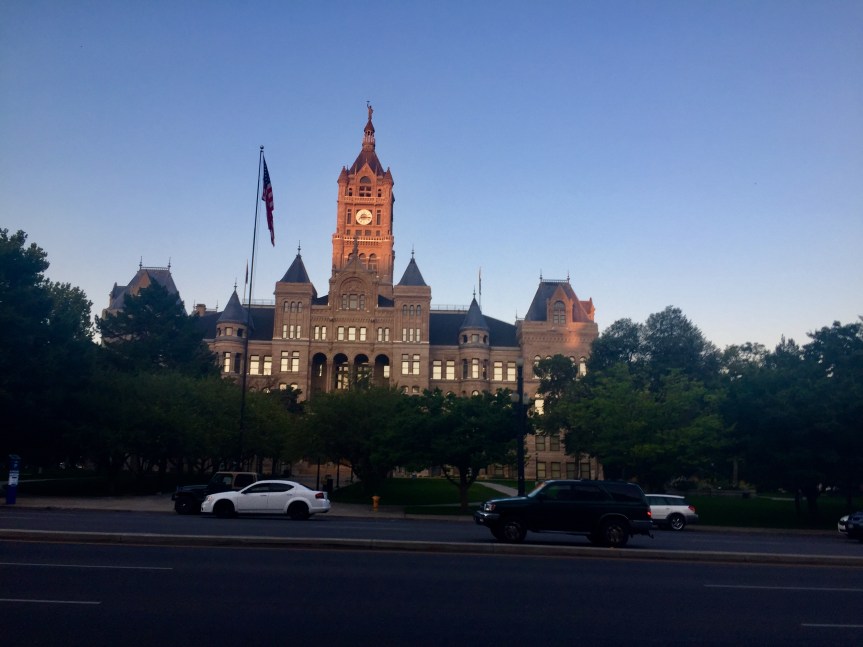
Salt Lake City and County Building
As far as the rest of our summer, it’s been great. We’ve gotten into a routine in our time here, so, while it might not be the most exciting, we’ve gotten to do the things we love: hike and drink good coffee and beer. The summers in Utah are HOT! It’s been great for getting to the pool, but there’s not a lot of shade in town so the sun can be a little unrelenting. Thankfully, the mountains are so close and we can hop in the car and be 20 degrees cooler in a quick 30 minutes. We also haven’t had much rain in the last 3 months so the grass is dry and wildfires are rampant. The skies have been pretty hazy and some mornings you can even smell the smoke. We actually saw a fire less than a mile from our apartment behind the Capitol!
We’ve spent a lot of time on the trails, both in town and in the mountains, and it’s been great. The wildflowers are in bloom and you can’t beat a mountain trail. Beth’s been training for a race in October and has logged quite a few miles on the trails with Matt and Snickers joining at the end as the support crew. We also managed to get out to a professional rugby game one weekend. The only place you won’t see a line at the beer stand during halftime!
With all of the travel, we haven’t tried too many new restaurants and breweries since our first update. We have managed to go back to a few favorites and have hit a handful of new “wins.” We tried RoHa the other week, and loved their selection on tap, plus their take-home high gravity beers. We also found some good lunch spots – Caputo’s deli for a meaty, Italian sandwich and Bagels and Greens for a bagel sandwich (Lox and Loaded is a go-to) that goes great with a cup of coffee. Speaking of coffee, Publik is a new favorite with bright, airy spaces and robust roasts. We’ve also hit up some nicer establishments for date night: Laziz Kitchen had some killer Mediterranean food, Water Witch was a nice, intimate spot for some pre-dinner cocktails, Takashi was amazing for sushi (we did omakase where we left the choice up to the chef and it was all so good; definitely worth the wait), and White Horse had tasty cocktails and tapas.
We never thought Utah would be the place we’d stay the longest (5 months!), but we’re really enjoying our time here.
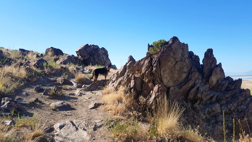
Frary Peak is a 7 mile out-and-back hike on Antelope Island. We did this as a sunset hike on the 4th of July. To read Matt’s full recap, check out our post: Antelope Island Sunset Hike.
The Double O Arch Trail is located in the Devil’s Garden area of Arches National Park. We left Snickers at the hotel for this one since dogs aren’t allowed on trails in the National Parks. To be honest, we didn’t make it all the way back to the Double O Arch because it was sunset and we wanted to be off the trail before dark, but there are many other arches along the trail. The trail starts on a flat, sandy surface and winds through the fins to the Landscape Arch, which at 290ft is the world’s longest arch! It then scrambles along some slickrock faces to a ridge line. This is where we turned around and stopped at Navajo Arch and Partition Arch on the return.
Corona Arch trail is a moderately trafficked 2.5 mile trail in Moab. The trail has a slight climb at the beginning and then winds along the smooth rock to the towering arch. There is a section that you have to climb rock using cables and another section with a ladder, but overall it was a fairly moderate hike. Dogs are allowed on the trail but may need some assistance on the cables/ladder portions. It was easily 100 degrees the day we went, so go early to try and beat some of the desert heat. The arch at the end is worth the sweat.
The Flying Dog trail from Spring Creek is a 16.5 mile trail in Park City. It is heavily used by mountain bikes, but if you get there early enough, you can get some decent hiking in. Beth did this as part of a training program and did the entire loop in the counterclockwise direction while Matt and Snickers did an out-and-back meeting up at their mile 5. The loop gains 2,000 ft elevation over the course of 16 miles, but there are long switchbacks that make it less daunting. The first few miles winds through some neighborhoods making its way into the Aspen forest. After mile 8, the trail is pretty much downhill to the end with a slight climb around mile 13. It was a good way to log some distance, but with all of the bikes, we probably wouldn’t do it again.
The Uinta National Forest is located near the high Uintas wilderness area of the Uinta Mountains – roughly 80 miles from downtown Salt Lake. The drive through the mountains is gorgeous as you ascend from the valley through Park City and into the pine forests of the Uintas. The trail itself is lightly-to-moderately trafficked and not too difficult. There are areas of climbing, but they are concentrated in small sections with most of the trail being relatively flat. It is a 4.2 mile loop that winds through the wilderness past many lakes. One thing we loved was just how many lakes are concentrated in a small area. The wildflowers were in full bloom at the end of July making for more gorgeous scenery.
The second week in July, we hit the road for Moab – about 230 miles, or just shy of a 4 hour drive southeast from Salt Lake City. Maybe it was a bit crazy to hike in the desert when the temps were in the 100s, but we were hell-bent on visiting the two National Parks in the area: Arches and Canyonlands.
Arches National Park
Balanced Rock – Arches National Park
Arches is located on the Colorado Plateau near the Colorado River. With over 2,000 arches, it has the largest concentration of natural arches in the world. The majority of the rock in the park is sandstone. The arches are formed as water seeped into cracks and through the freeze-thaw cycle ice created pressure breaking off parts of the rock. As wind cleaned out loose particle, fins remained, which further give way to water and wind and became arches. You can see the some of the progress below – the pictures on the right shows the fin stage while the one on the left shows an arch. Fun fact, Skyline Arch (pictured in the photo on the right below) was actually only half that size until 1940 when a boulder fell out and doubled the opening. While we didn’t get to the most famous arch in the park – Delicate Arch – there are so many other beauties to see.
Fins at Arches
Skyline Arch
We went in the evening to beat the heat, and while it was still in the 90s the shade made it much more bearable. We drove through the park stopping at Balanced Rock and Skyline Arch before hiking through Devil’s Garden. We passed the Landscape Arch, which is one of the longest arches in the world, before climbing up the rock face to head back toward Double O Arch. We ended up turning around before we got there because the sun was setting and we didn’t want to be scrambling in the dark, but we were able to stop at the Partition and Navajo Arches on the way back. In the dark, we pulled up to the Delicate Arch viewpoint to try and capture it with a long exposure.
Balanced Rock
Landscape Arch
Partition Arch
Delicate Arch at night
Corona Arch
Corona Arch is located along a trail in a side canyon along the Colorado River. The arch is partially free-standing and has an impressive 140 ft x 105 ft opening. The trail is relatively easy with only a few short, steep sections, and is 2.3 miles round trip. It’s easy to follow with cairns and green paint to mark the way. While summer is probably not the most ideal time to hike in Moab, we went early in the morning before the sun got too high in the sky. This allowed for some shade along the way from the canyon walls and we were able to finish before the trail got too crowded. We ended the hike with a quick splash (for the dog) in the Colorado River.
Canyonlands National Park
Canyonlands National Park covers over 330,000 acres of land in southeastern Utah. It is one of the more remote National Parks with very little for services throughout; the NPS encourages you to take anything you might need for your visit with you due to the remoteness. The park is divided into three “districts” that are bounded by the Colorado and Green Rivers. You cannot access the different areas from within the park as there are no roads that cross the rivers. To get from one district to the next is anywhere from a 2-6 hour car ride.
The three districts that make up Canyonlands are: Island in the Sky, The Needles, and The Maze. Island is the Sky, with its proximity to Moab, is the most highly visited area. Island in the Sky is a sandstone mesa that sits over 1,000 above the surrounding terrain. We visited the Grand Viewpoint, which is at the southernmost point of the scenic drive. It gives a great vista of the White Rim – a sandstone formation above the river convergence, as well as The Needles and The Maze.
The Needles is east of the Colorado River and is named after rock pinnacles that can be found in the landscape. The Needles was once the home of Pueblos, and there are still traces of their heritage including well-preserved petroglyphs. The Maze is located to the west of the Colorado and Green Rivers and is the most primitive area in Canyonlands. It is also one of the most remote and inaccessible areas in the entire United States, which has led to it being called on of the most dangerous places to hike. It has many geological features unique to the area including Orange Cliffs and Golden Stairs.
Beth and Casey came to visit us back in June, and we road tripped to southern Utah to take in the sights. Utah is home to 5 National Parks, third only to Alaska and California, which both boast 8. Not only does Utah have these gorgeous parks, but it also ranks 3rd for most federally owned land – this includes not only the National Parks, but National Monuments, National Forests, and wilderness areas, to name a few. This is especially important because these publicly-owned lands provide protections to the land and wildlife, ensuring their preservation for the future.
We could go on and on about the benefits of preserving nature and how we shouldn’t be stripping those protections away, but that’s a post for another day :).
Back to our trip. We loaded up the car early Saturday morning heading to our final destination – Zion National Park. Since Utah has such amazing scenery and a high concentration of these lands are in the south, we made sure to detour and see as much as possible. On the list: Grand Staircase Escalante National Monument, Dixie National Forest, Bryce Canyon National Park, Zion National Park, and Cedar Breaks National Monument. For more about our hikes through all of these parks, check out our post on June 2018 Hikes.
Grand Staircase Escalante National Monument
Grand Staircase Escalante – whose name derives from the Escalante River and geological “steps” corresponding to various time periods over millions of years – stretches from Bryce Canyon to the Grand Canyon. It is among some of the most remote in the country and was the last part of the contiguous United States to be mapped. There are five “steps” in the Grand Staircase: the pink cliffs formed of pink and red limestones that has many different rock formations including Bryce Canyon’s famous hoodoos; grey cliffs made of Cretaceous sandstone comprising the area between Bryce Canyon and Zion; white cliffs formed of Navajo sandstone and home of the majestic cliffs of Zion; the vermillion cliffs made of silt and found near Kanab; and the chocolate cliffs, which are the oldest formed of Kaibab limestone and makes the North Rim of the Grand Canyon. Needless to say, the sights were spectacular. Driving through the changing landscapes and noting the different geologic periods that made this possible kept us in awe of just how small we are in the grand scheme of things.
Bryce Canyon National Park
Bryce Canyon National Park has the highest concentration of hoodoos in the world. It’s at 8,000-9,000 ft elevation at the rim, which looks out over the canyon filled with hoodoos. Bryce Canyon is technically not a canyon, but an amphitheater created by headward erosion wherein erosion occurs at the origin of a stream in the opposite direction of the flow. This erosion has led to the exposure of hoodoos where a layer of soft rock (typically mudstone) has been covered by a layer of hard rock (limestone, sandstone) leaving spires. We only made it to Sunrise-Sunset point, where the views were spectacular, but there are many other viewpoints and hikes throughout the park.
Zion National Park
Zion National Park could have an entire post of its own. After visiting a handful of National Parks in the last couple of months, what struck us most about Zion is how majestic it is. While the park actually encompasses a large area from Zion Canyon to Kolob Canyon, most people only go through Zion Canyon in the southern end of the park. The north fork of the Virgin River cut through the Navajo sandstone creating looming, red cliffs. The park winds through a canyon, and due to the small size and high traffic is only accessible by shuttle in the summer months. There are plenty of trails and sights to see through the canyon including the Court of Patriarchs – a trio of peaks named after biblical figures Abraham, Isaac, and Jacob, Angel’s Landing – a rock formation that got its name because it appears that only angels could summit, and the famous narrows – the narrowest section of the canyon and an incredibly popular hike. We didn’t get to hike Angel’s Landing this time, but it’s on our list for our next visit.
Cedar Breaks National Monument
Cedar Breaks is off the beaten path and easy to skip even if you’re in the area, but we would highly recommend visiting. It’s a natural “amphitheater” that stretches 3 miles wide and 2,000 feet deep. It’s not an amphitheater in the casual sense – no concerts are held there – but it is a rock formation that naturally amplifies sound. It is at 10,000 feet elevation and has rock formations similar to Bryce Canyon. We only ventured along the rim, but were awestruck by the magnitude of the space and just how far you could see out into the valley.
Dixie National Forest
Dixie National Forest is the largest forest in Utah, stretching across 2 million acres at the southern end of the state. In fact, most of the above national lands lie within the areas of Dixie. We were constantly passing through the forest as we wound our way to all of the National Parks and Monuments. The area is composed of many different ecosystems and is quite beautiful to behold.
To note: National Parks are not dog-friendly, but National Monuments and National Forests are.
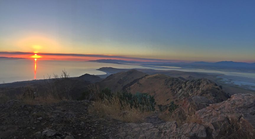
Independence Day we decided to head out for a sunset hike on Antelope Island in the middle of the great Salt Lake! It was _hot_ and the evening sun provided no relief. The views were fantastic from the top of Frary trail, a 7.3 mile out-and-back, the sunset gorgeous, but the fireworks were but small twinkles in the city skyline 30-miles away!
Hot Frary Trail hike
We started at 6pm and it was still in the upper 90’s, sun blazing. It is an hour drive from SLC because the only way to the island is over a land bridge on the North side of the island. After we entered, we were treated to views of hundreds of bison (buffalo??) right from the car. Looks like they were trying to cool off on the salty beaches.
Frary Trail is rated Hard on Alltrails.com and it earns primarily through zero shade, a good, 2,300 ft climb, and some rocky terrain inside a 3.1 mile trail (plus the return). We were a bit worried about how many people might be out there for a sunset hike on July 4th, due to fireworks. However, we only met 1 person returning when we got to the trailhead!
The trail offered a beautiful, rolling grasslands, with plenty of wildlife and quite a few exposed rocks. Apparently these are some of the oldest rocks around! Definitely not what we expected seeing the island from SLC. The pup was ready for action and did very well, but she was feeling the heat by the time we hit the top of the mountain.
We ran into some antelope(??) on our way up- they were crossing the field in front of us, just a hundred feet or so. They were really eye-ing us up, so we waited and they meandered across the path. We saw a few more scattered around the paths as the sun set.
The last leg of the hike is a bit of challenge- it offers 2 paths. One is across a craggy ridgeline that is really not meant to be hiked at all, and the second is down and then up and up a pretty well-marked path.
Golden hour makes for some fantastic shots
Take a look at the shot I capture of Beth during the last hour or so of sunlight. Fantastic shadowing at this faux-peak about a half mile still to go.
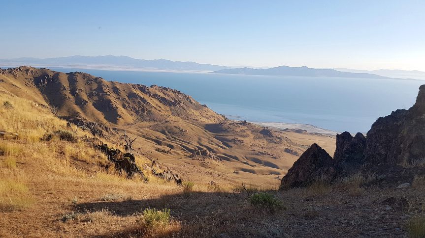
Sunset at the peak offers spectacular 360
The real show was at the the peak at 6,445 ft of elevation. You are able to see 360 and miles and miles in every direction. Salt Lake City sits due East about 30 miles as the crow flies and makes for a humbling setting in front of the mountain range. The real show is to the West, with the sunset over the far mountains and the Salt Lake.
When we hit the top we were joined not long after by a few more folks: a couple single hikers plus a group of 4 that was struggling to get up… Looks like they were planning to have a few drinks and stay up past the fireworks. They were going to be in for an unpleasant return hike.
Dark, dark return hike
We started down the return around 10pm, just as the sun had set. We still had some light for the most difficult half mile; however, that bit of good fortune quickly ended as the sky grew darker. When the sun sets out on Antelope Island it is DARK. Not true International Dark Sky’s dark, but no artificial lights outside SLC. We had a heck of time coming down the entire trail after nautical twilight. We really had to pick around the rocks in the trail that hadn’t even given us notice on the way up. On top of that, we heard animals… I mean, all kinds of them. We heard coyotes as soon as the sun set, the bleating of the deer and antelope in the distance, and the constant, low rumbling of the bison(!!!) at the lower elevation. On top of that, there are many large rocks sticking out of the ground, just outside flashlight view that at every turn make you think you’re going to run right into one of those big things. It really felt like being out in nature.
For the dog, the return hike was just… miserable. We would highly discourage folks from making the dark decent with their furry friend. It was hard for us to see, but impossible for the dog to see, so it was slow going picking through the trail.
The fireworks were but small twinkles
So, what about the FIREWORKS! It is July 4, after all. Well… We were able to see some grand city views on our return hike. The fireworks, though, were only small twinkling lights that must have been spaced every city block. In fact when I first saw them, I thought I was looking at blinking street lights. It’s amazing how small the fireworks look at such a distance when they look so big and beautiful when you are beneath them! The whole of the greater Salt Lake City area was twinkling the entire time we descended.
It was a long, dark, and lonely drive back to civilization off the island… very appropriate way to end it!


 (
(
 (
(


 (
(